
Ever wonder what America would look like if each state were equal in population?
An artist and urban planner has redrawn the map of the United States to show what it would look like if the same number of people occupied each state.
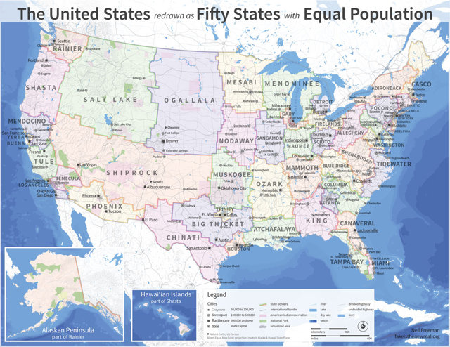
Neil Freeman’s “United States redrawn as Fifty States with Equal Population” takes a radically simple stab at Electoral College reform, preserving its structure and function while simultaneously ending the overrepresentation of small states and underrepresentation of large states in presidential voting by eliminating small and large states altogether.
Using data from the 2010 U.S. Census, Freeman says his map’s redrawn boundaries “more closely follow economic patterns, since many states are more centered on one or two metro areas.” It also would end varying representation by population in the U.S. House.
“Currently, the population of House districts ranges from 528,000 to 924,000,” Freeman writes. “After this reform, every House seat would represent districts of the same size.”
Each state in Freeman’s redrawn America has a population of roughly 6,175,000.
Many state capitals were maintained in Freeman’s configuration; otherwise, large or central cities were chosen. Suggested names of the new states, he adds, were taken mainly from geographical features, including mountain ranges (Adirondack, Blue Ridge, Ozark), peaks (Mammoth), rivers (Susquehanna), lakes (Salt Lake), plants (Yerba Buena) and even caves (Shiprock).