
The discovery comes from researchers led by The Ohio State University, who have recorded GPS measurements that show West Antarctic bedrock is being pushed sideways at rates up to about twelve millimeters–about half an inch–per year. This movement is important for understanding current ice loss on the continent, and predicting future ice loss.
They reported the results on Thursday, Dec. 12 at the American Geophysical Union meeting in San Francisco.
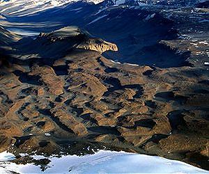
Half an inch doesn’t sound like a lot, but it’s actually quite dramatic compared to other areas of the planet, explained Terry Wilson, professor of earth sciences at Ohio State. Wilson leads POLENET, an international collaboration that has planted GPS and seismic sensors all over the West Antarctic Ice Sheet.
She and her team weren’t surprised to detect the horizontal motion. After all, they’ve been using GPS to observe vertical motion on the continent since the 1990’s.
They were surprised, she said, to find the bedrock moving towards regions of greatest ice loss.
“From computer models, we knew that the bedrock should rebound as the weight of ice on top of it goes away,” Wilson said. “But the rock should spread out from the site where the ice used to be. Instead, we see movement toward places where there was the most ice loss.”
The seismic sensors explained why. By timing how fast seismic waves pass through the earth under Antarctica, the researchers were able to determine that the mantle regions beneath east and west are very different. West Antarctica contains warmer, softer rock, and East Antarctica has colder, harder rock.
Stephanie Konfal, a research associate with POLENET, pointed out that where the transition is most pronounced, the sideways movement runs perpendicular to the boundary between the two types of mantle.