
Short Background: Atlantis (Ancient Greek: Ἀτλαντὶς νῆσος, “island of Atlas”) is a ‘fictional’ island mentioned within an allegory on the hubris of nations in Plato’s works Timaeus and Critias, where it represents the antagonist naval power that besieges “Ancient Athens”, the pseudo-historic embodiment of Plato’s ideal state in The Republic.
In the story, Athens repels the Atlantean attack unlike any other nation of the known world, supposedly giving testament to the superiority of Plato’s concept of a state. The story concludes with Atlantis falling out of favor with the deities and submerging into the Atlantic Ocean.
Despite its minor importance in Plato’s work, the Atlantis story has had a considerable impact on literature. The allegorical aspect of Atlantis was taken up in utopian works of several Renaissance writers, such as Francis Bacon’s New Atlantis and Thomas More’s Utopia.
On the other hand, nineteenth-century amateur scholars misinterpreted Plato’s narrative as historical tradition, most notably in Ignatius L. Donnelly’s Atlantis: The Antediluvian World. Plato’s vague indications of the time of the events—more than 9,000 years before his time—and the alleged location of Atlantis—”beyond the Pillars of Hercules”—has led to much pseudoscientific speculation. As a consequence, Atlantis has become a byword for any and all supposed advanced prehistoric lost civilizations and continues to inspire contemporary fiction, from comic books to films.
While present-day philologists and classicists agree on the story’s fictional character, there is still debate on what served as its inspiration. As for instance with the story of Gyges, Plato is known to have freely borrowed some of his allegories and metaphors from older traditions.
This led a number of scholars to investigate possible inspiration of Atlantis from Egyptian records of the Thera eruption, the Sea Peoples invasion, or the Trojan War. Others have rejected this chain of tradition as implausible and insist that Plato created an entirely fictional nation as his example, drawing loose inspiration from contemporary events such as the failed Athenian invasion of Sicily in 415–413 BC or the destruction of Helike in 373 BC.
The Mystery School Knowledge:
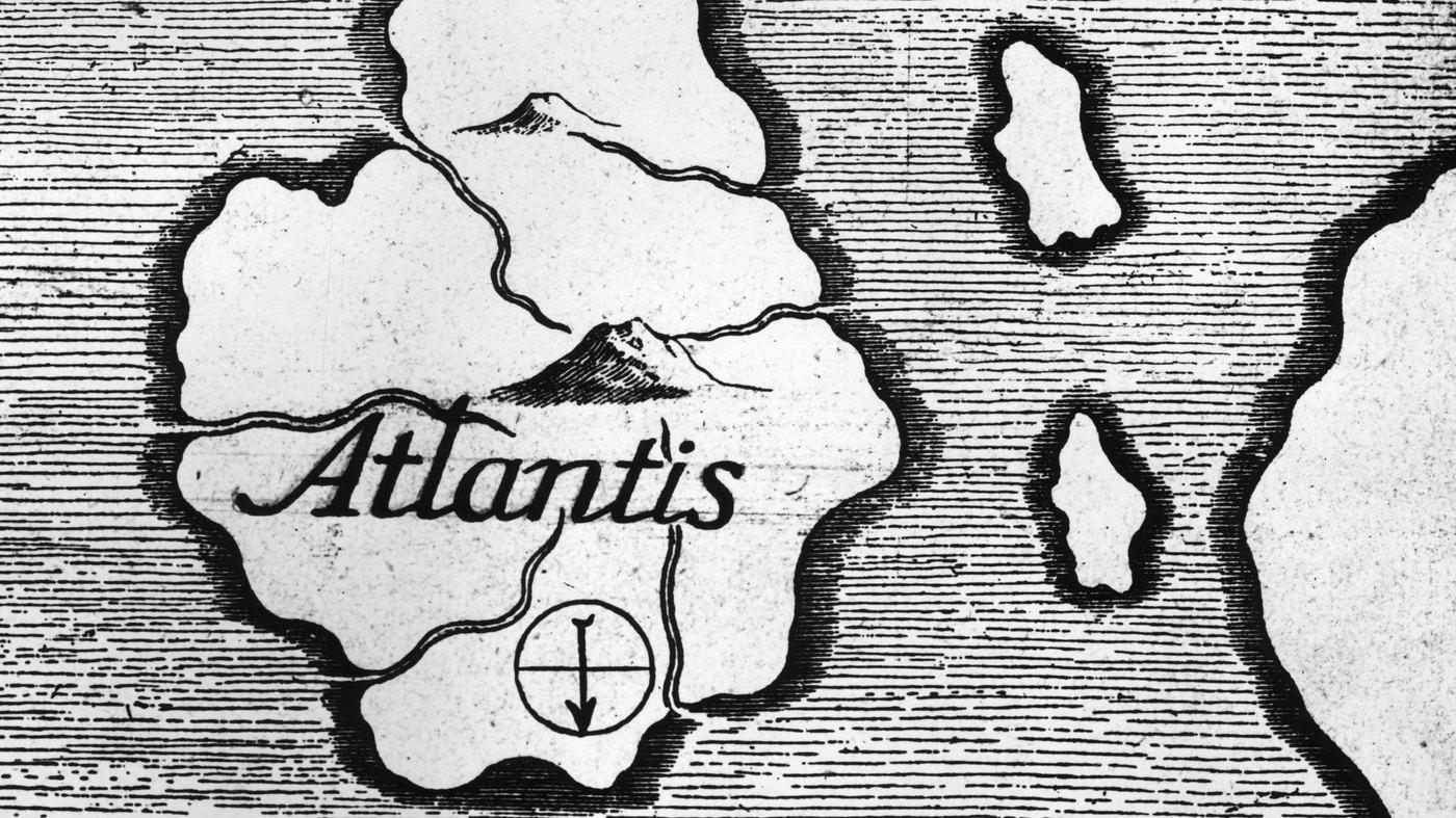
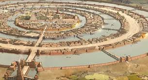
Atlantis according to Plato, a stunningly gorgeous and opulent place, built upon concentric circles of land and water. It was wealthy and powerful beyond measure until, in the course of one day and one night, the whole thing went sideways and a cataclysm wiped the city of Atlantis off the map and out of the history books. According to some esoteric traditions, Atlantis was the birthplace of the so-called “Mystery Schools” that wove their way through western philosophy after the city’s destruction.
Herodotus of Halicarnassus

The “Father of History” mentions Atlantis with not a single word. However his historical work is crucial for the Atlantis problem. Why this? First of all Herodotus lived very near in time and space to the persons and places related to the assumed historical tradition of the Atlantis account: Around 450 BC Herodotus travelled to Egypt and came by the city of Sais, where he visited the temple of the goddess Neith.
From this temple Solon is said to have brought the Atlantis account to Greece around 140 years before Herodotus’ visit. Plato most probably has been to Egypt, too, around 50 years after Herodotus’ visit to Egypt. When Plato composed the Atlantis account as we know it today a further 40 years later, Herodotus’ Histories were known to everybody.
So they contributed heavily to Plato’s geographical and historical background, which could help to explain Plato’s understanding and interpretation of the Atlantis account. Herodotus did not only visit the temple of Neith in Saitic Egypt at a time when the historical tradition from Solon to Plato still had been in progress, but Herodotus also touches a wide variety of topics, which have a key position for answering the question of Atlantis:
Herodotus describes in detail a map of all regions and countries of the whole world known at his time. He talks about geological findings, sinking islands and natural disasters. He presents the history of peoples and empires he visited. He especially gives insight into the Egyptian culture and chronology as he saw them. By this Herodotus provides us with a lot of clues how to interpret the Atlantis account in geographical, historical, literary and many other perspectives. Furthermore Herodotus’ Histories contain a lot of similarities, analogies and parallels to Plato’s Atlantis account. Among these are assumedly similar buildings and city plans, analogous chronological data or similar information about the mentality of Egyptian priests.
Did Plato copy parts of his Atlantis account from Herodotus? Or are the assumed similarities not that strong as they seem to be at first glance? Are strong similarities a clue for an invention of the Atlantis account or – in contrary – are loose similarities a clue for the reality of the Atlantis account, since similarities do show, that Plato’s Atlantis is not a surrealistic product of mere fantasy but stays within the possibilities of the ancient world’s reality? Even where Herodotus makes mistakes he helps us to reach a better understanding for Plato’s Atlantis account. If we know, where and why Herodotus’ Histories contain mistakes we get a better idea, which parts of the Atlantis account are correct and which are not, assumed it is not an invention but a historical tradition. As with Plato we also have to become clear about the person of Herodotus and about the question, whether we can trust in Herodotus as a credible reporter. Are Herodotus’ mistakes unintentional mistakes or – in contrary – deceitful inventions, which makes a big difference of course.
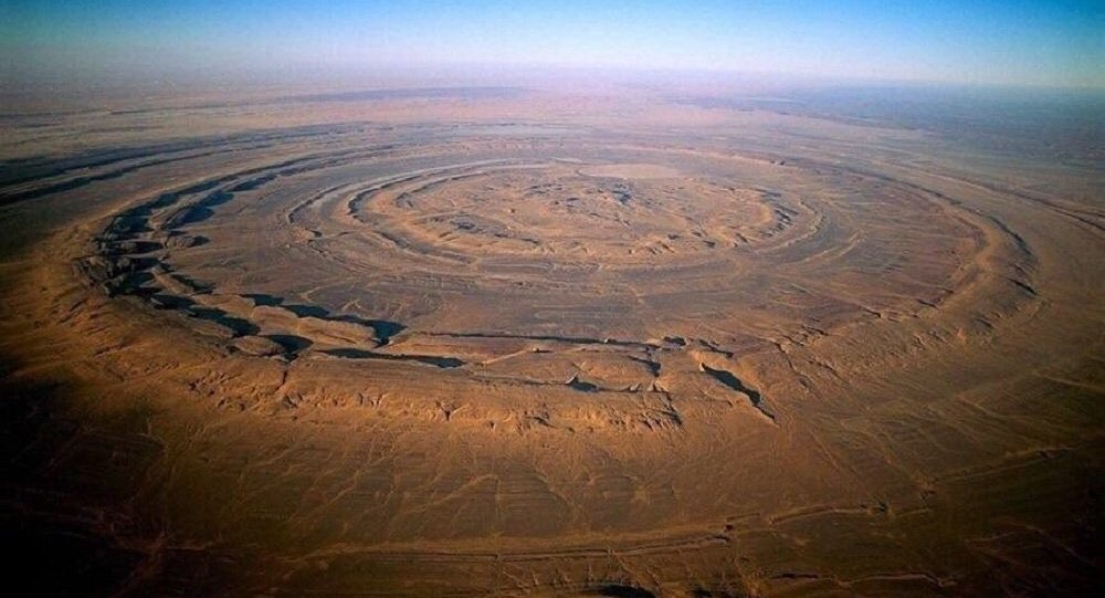
Herodotus Map – B,C 450
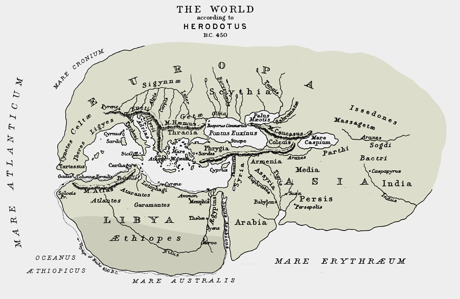
Now you can see that the map created in B.C 450; Atlantis is clear written on it. Then in today’s modern world will bring you to modern day Africa. There is a very interesting deeply eroded, slightly elliptical dome unlike anywhere else on earth. This is called:
The Richat structure:
This earthen structure of unknown origin in Mauritania, on the northwest coast of Africa. It consists of concentric circles of raised ground, bordered by mountains to the north and facing the sea to the south.
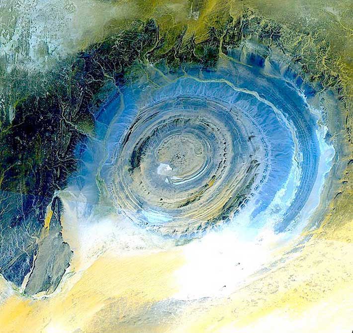
Plato states that the city of Atlantis was 127 stadia in diameter. According to Dictionary.com, one stadia is approximately 607 feet. This is the conversion used in the video, which works out to 127 stadia equaling 77,089 feet and 23.49 kilometers. Measuring the Richat structure in Google Earth gives a diameter of between 22 and 24 kilometers. That’s pretty close to the measurements for Atlantis. However, other sources say that a stadia is between 607 and 630 feet, which doesn’t seem like a big difference until you realize that 27 feet of variance per stadia, multiplied by 127 stadia, comes out to 3429 feet.
The surrounding areas match the description of Atlantis fairly note-for-note as well. Plato describes the city as being bordered to the north by mountains notable for their great number and beauty. The Richat structure is indeed ringed by mountains to the north.
Further arguments made include the timeline of the fall of Atlantis matching up pretty nicely with the proposed date of the Younger Dryas impact hypothesis, which argues that the impact of a comet or asteroid triggered the Younger Dryas period of rapid and sudden climate change and sea level variation.
Whats kind of stone is it made of?
The sedimentary rock exposed in this dome ranges in age from Late Proterozoic within the center of the dome to Ordovician sandstone around its edges. The sedimentary rocks composing this structure dip outward at 10–20°. Differential erosion of resistant layers of quartzite has created high-relief circular cuestas. Its center consists of a siliceous breccia covering an area that is at least 30 kilometres (19 mi) in diameter.[
Exposed within the interior of the Richat Structure are a variety of intrusive and extrusive igneous rocks. They include rhyolitic volcanic rocks, gabbros, carbonatites and kimberlites. The rhyolitic rocks consist of lava flows and hydrothermally altered tuffaceous rocks that are part of two distinct eruptive centers, which are interpreted to be the eroded remains of two maars. According to field mapping and aeromagnetic data, the gabbroic rocks form two concentric ring dikes. The inner ring dike is about 20 m in width and lies about 3 km from the center of the Richat Structure. The outer ring dike is about 50 m in width and lies about 7 to 8 km from the center of this structure. Thirty-two carbonatite dikes and sills have been mapped within the Richat Structure. The dikes are generally about 300 m long and typically 1 to 4 m wide. They consist of massive carbonatites that are mostly devoid of vesicles. The carbonatite rocks have been dated as having cooled between 94 and 104 million years ago. A kimberlitic plug and several sills have been found within the northern part of the Richat Structure. The kimberlite plug has been dated to around 99 million years old. These intrusive igneous rocks are interpreted as indicating the presence of a large alkaline igneous intrusion that currently underlies the Richat Structure and created it by uplifting the overlying rock.[
Spectacular hydrothermal features are a part of the Richat Structure. They include the extensive hydrothermal alteration of rhyolites and gabbros and a central megabreccia created by hydrothermal dissolution and collapse. The siliceous megabreccia is at least 40 m thick in its center to only a few meters thick along its edges. The breccia consists of fragments of white to dark gray cherty material, quartz-rich sandstone, diagenetic cherty nodules, and stromatolitic limestone and is intensively silicified. The hydrothermal alteration, which created this breccia, has been dated to have occurred about 98.2 ± 2.6 million years ago using the 40Ar/39Ar method.
Archaeology
The Richat structure, also known as the Guelb er-Richât in the Mauritanian Adrar is the location of exceptional accumulations of Acheulean artifacts. These Acheulean archaeological sites are located along wadis that occupy outermost annular depression of this structure. Pre-Acheulean stone tools also have been found in the same areas. These sites are associated with rubbly, chaotic outcrops of quartzite that provided the raw material needed for the manufacture of these artifacts.
The most important Acheulean sites and their associated outcrops are found along the north-west of the outer ring, from which Wadi Akerdil heads east and Wadi Bamouere to the west. Sparse and widely scattered Neolithic spear points and other artifacts have also been found. However, since these sites were first discovered by Theodore Monod in 1974, mapping of artifacts within the area of the Richat structure have found them to be generally absent in its innermost depressions.
So far, neither recognizable midden deposits nor manmade structures have been recognized and reported from the Richat structure. This is interpreted as indicating that area of the Richat structure was used only for short-term hunting and stone tool manufacturing. The local, apparent wealth of surface artifacts is the result of the concentration and mixing by deflation over multiple glacial-interglacial cycles.
Artifacts are found, typically redeposited, deflated, or both, in Late Pleistocene to early Holocene gravelly mud, muddy gravel, clayey sand, and silty sand. These sediments are often cemented into either concretionary masses or beds by calcrete.
Ridges typically consist of deeply weathered bedrock representing truncated Cenozoic paleosols that formed under tropical environments. The Pleistocene to Middle Holocene sediments occur along wadis as thin, meter- to less than meter-thick accumulations in the interior annular depressions to 3–4 meters (9.8–13.1 ft) thick accumulations along the wadis in the outermost annular depression of the Richat structure.
The gravelly deposits consist of mixture of slope scree, debris flow, and fluviatile or even torrential flow deposits. The finer grained, sandy deposits consist of eolian and playa lake deposits. The latter contain well-preserved, freshwater fossils. Numerous, concordant radiocarbon dates, indicate that the bulk of these sediments accumulated between 15,000 and 8,000 BP during the African humid period. These deposits lie directly upon deeply eroded and weathered bedrock
Large Ancient River System:
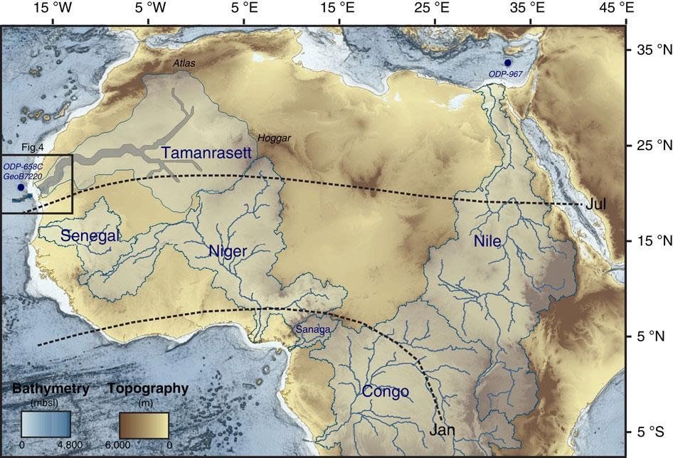
As recently as 5,000 years ago, one of the world’s driest and most uninhabitable places, the Western Sahara desert, was home to a vast river system that would rank as the world’s 12th largest drainage basin if it existed today. French researchers have identified an ancient river system that they believe formed during humid spells that overtook the desert over the past 245,000 years, according to a study published this week in the journal, Nature Communications. Using an advanced imaging system on the Japanese Advanced Land Observing Satellite, Charlotte Skonieczny, from the L’Institut Français de Recherche pour l’Exploitation de la Mer, and her team, found sediment layers typical of river-borne material that outlined a river stretching about 500km (320 miles) long. Researchers said that with this river system, the Sahara would have once been the “location of extensive vegetation, animal life and human settlements.”
Atlas of Mauretania?
“Atlas of Mauretania,” a famous philosopher, mathematician, and astronomer, who also was king of Mauretania. Not very much is known about this man, however. Wikipedia has next to nothing.
“Mauri,” from which “Mauretania” is derived, was the Roman term for the Berber kingdoms of North Africa. But this is also where the Atlas mountains are located. In fact ádrār in Berber means “mountain.” The Atlantic Ocean was named after Atlas and so was the lost island of Atlantis. Moroccans seem to have been great geographers. Ibn-Batuta was from Morocco too.
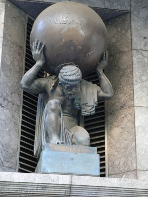
Atlas was also a legendary king of Mauretania, the land of the Mauri in antiquity roughly corresponding with modern Maghreb. In the 16th Century Gerardus Mercator put together the first collection of maps to be called an “Atlas” and devoted his book to the “King of Mauretania”.
Atlas became associated with Northwest Africa over time. He had been connected with the Hesperides, “Nymphs” which guarded the golden apples, and Gorgons both of which lived beyond Ocean in the extreme west of the world since Hesiod’s Theogony. Diodorus and Palaephatus mention that the Gorgons lived in the Gorgades, islands in the Aethiopian Sea. The main island was called Cerna and modern day arguments have been advanced that these islands may correspond to Cape Verde due to Phoenician exploration.
The Northwest Africa region emerged as the canonical home of the King via separate sources. In particular, according to Ovid, after Perseus turns Atlas into a mountain range, he flies over Aethiopia, the blood of Medusa’s head giving rise to Libyan snakes. By the time of the Roman empire the habit of associating Atlas’ home to a chain of mountains, the Atlas mountains, which were near Mauretania and Numidia, was firmly entrenched.
King of Atlantis
According to Plato, the first king of Atlantis was also named Atlas, but that Atlas was a son of Poseidon and the mortal woman Cleito. The works of Eusebius and Diodorus also give an Atlantean account of Atlas. In these accounts, Atlas’s father was Uranus and his mother was Gaia. His grandfather was Elium “King of Phoenicia” who lived in Byblos with his wife Beruth. Atlas was raised by his sister, Basilia.
Conclusion: So the interesting part of this and why I have posted all the information for research because it might provide some valuable paths on finding Atlantis. But seriously both the Names are Atlas for two completely ‘different’ locations? Seems a coincidence. Right? Or are we talking about the same place? Because don’t forget where the King of Mauretania ruled that interesting rock formation. So do we have a connection between Atlantis and Africa? Much further research is needed to be for sure. Good luck trying to do your own excavations. I will do another post when I find more information on the hunt.