
This is breaking news: Hurricane Irene will hit the east coast starting on Saturday.. People are already evacuating from orders of the National Guard. The highways are jammed, the stores are bare and people are scared! Not to mention we had the Earthquake a couple days ago which started in Virginia and was felt in New Jersey, New York, and even Canada! I have been preparing for this Hurricane; That’s why I haven’t been posting as much as I usually do. (Sorry) But I decided to do a quick post about this east coast disaster including the Earthquake to get the facts across.. Something seems weird about these disasters; could ELENIN be getting closer to earth? Or does HAARP have something to do with this? Could the recent sightings of huge Chemtrails also have a role in creating this disaster? I don’t know but I’m going to include some research below and if you have family or if your on the East Coast; please prepare!!

Earthquake News
The quake could be felt in McLean, Va., headquarters of USA TODAY. It caused the building to sway. Some items could be heard falling from shelves. A number of employees went left the building.
Update at 2:10 p.m. ET: NBC reports that the quake was centered nine miles from Mineral, Va., which is 100 miles south of Washington, D.C.
Says Doug Kammerer, meteorlogist with the NBC affiliate in Washington, calls the tremor a “very big earthquake for our area.” The quake struck around 1:15 p.m. ET and lasted for about 30 to 45 seconds. There have been no reports of injuries or widespread damage.
Update at 2p.m. ET: Reuters reports a 6.0 magnitude earthquake centered near Mineral, Va., rocked the mid-Atlantic states and was felt as far north at Manhattan and as far south as North Carolina.
Update at 1:57 p.m. ET:The Associated Press reports that the Pentagon is being evacuated.
An apparent earthquake rocks Washington, D.C. area. Fox news reports that several public buildings, including the Capitol, have been evacuated.
Source
Could This Have Been The Cause Of The ‘Earthquake’? A Nuclear Explosion Underground?!
A frightening foreign military intelligence directorate (GRU) report circulating in the Kremlin today states that over the past nearly 36 hours the vast intercontinental military tunnel complex constructed by the United States Air force over the past nearly 45 years was hit with two powerful nuclear explosions at its main terminuses in Colorado and Virginia used nearly exclusively by the Central Intelligence Agency (CIA).
According to this report, this unprecedented nuclear attack began on the evening of 22 August when one of the main air pressure relief tunnels for this CIA tunnel, located at MacDill Air Force Base in Tampa Florida, was forced open allowing millions of cubic feet of air to rush suddenly into the atmosphere. The unique sound of this event was captured by video [3rd video] during a baseball game being played at
Tropicana Field near MacDill, though US officials blamed the “mystery noise” on a faulty sound system. This GRU report, however, points out that Russian engineers are well acquainted with this unique sound as they work feverishly to prepare an additional 5,000 bomb shelters ordered by Prime Minister Putin this past spring to be completed by the end of 2012.
Russian engineers were, also, able to duplicate this unique sound this past March when they were called into the Ukraine to vent a number of deep underground tunnels from poison gas that had killed three people near Kiev and which was, likewise, captured by video.
Source
This Earthquake Tied The Record Which Was Back In 1897
Giles County, Virginia
1897 05 31 18:58 UTC
Magnitude 5.9
Intensity VIII
This earthquake was the largest in intensity and aerial extent in Virginia in historical times. MM intensity VII to VIII extended over an elliptical area – from near Lynchburg, Virginia, west to Bluefield, West Virginia, and from Giles County south to Bristol, Tennessee. The MM intensity VIII assigned to this earthquake is based on “many downed chimneys” and “changes in the flow of springs.”
The shock was felt severely at Narrows, about 3 kilometers west of Pearisburg. Here, the surface rolled in an undulating motion, water in springs became muddy, and water in some springs ceased to flow. The flow of water in springs also was disturbed in the area of Pearisburg, about 70 kilometers west of Roanoke, and Sugar Run.
The shock was strong at Pearisburg, where walls of old brick houses were cracked and many chimneys were thrown down or badly damaged. Many chimneys also were shaken down at Bedford, Pulaski, Radford, and Roanoke, Virginia, and Bristol, Tennessee; many chimneys were damaged at Christiansburg, Dublin, Floyd, Houston, Lexington, Lynchburg, Rocky Mount, Salem, Tazewell, and Wytheville, Virginia; Charlotte, Oxford, Raleigh, and Winston, North Carolina; Knoxville, Tennessee; and Bluefield, West Virginia. Felt from Georgia to Pennsylvania and from the Atlantic coast westward to Indiana and Kentucky. Aftershocks continued through June 6, 1897.
Source
Quake damages National Cathedral, Ecuador embassy
The Washington National Cathedral, the highest building in the city, suffered damage in Tuesday’s earthquake, with three pinnacles in the central tower breaking off, a spokesman said.
Richard Weinberg, director of communications at the Episcopal cathedral, said a fourth pinnacle was leaning and might also be damaged. The building’s central tower, which is 30 stories high, also suffered minor structural damage.
Other damage reported from the earthquake occurred at the Ecuador Embassy, a recorded message by the DC Fire and EMS agency said.
Source

FNC reports Washington Monument may be tilting from quake jolt
Fox News anchor Megyn Kelly reported at 2:30 pm that their bureau received information from a producer saying that a Captiol Hill Police officer says that the Washington Monument may actually be tilting as a result of the earthquake.
Seismologist John Rundle joined Kelly on her show and confirmed that the Washington Monument could very well be tilting as a result of the earthquake and the structure should be checked out.
Source
Virginia Nuclear Power Plant Loses Power After Quake
A nuclear power plant in central Virginia has lost offsite power in the wake of a 5.9 earthquake centered northwest of Richmond, Va., U.S. nuclear officials said.
The North Anna Power Station, which has two nuclear reactors, is now using four diesel generators to maintain cooling operations. The plant automatically shut down in the wake of the earthquake.
“As far as we know, everything is safe,” said Nuclear Regulatory Commission spokesman David McIntyre.
There are seven additional nuclear plants that have declared unusual events, which is the lowest of four emergency situations, the NRC said.
Those plants are located in Virginia, Maryland, Pennsylvania and New Jersey.
Source

Washington Monument top cracked by earthquake
The National Park Service says engineers have found a crack near the top of the Washington Monument presumably caused by a magnitude-5.8 earthquake that shook the East Coast.
Park service spokesman Bill Line said Tuesday night that structural engineers found the crack where the 555-foot landmark narrows considerably.
He says the monument will be closed indefinitely to keep the public safe.
An outside engineering service will study the crack on Wednesday.
The 91,000-ton monument is made of Maryland marble.
Source
USGS Warns it May be a Foreshock
According to the United States Geological Survey (USGS), the quake happened at 1:51 p.m. at a depth of 3.7 miles. The quake was centered 27 miles east of Charlottesville, Va., near the town of Mineral in Louisa County, Va.
Minutes after the quake, the director of the USGS, Marcia McNutt — who watched objects falling from the shelves in her office — cautioned that the shaking might not be over.
“What the concern is, of course, is that this is a foreshock. If it’s a foreshock, then the worst is yet to come,” McNutt told The Washington Post.
Residents in Northern Virginia described it like “a freight train coming through the house.”
Source
Quake sensors removed around Virginia nuke plant due to budget cuts
A nuclear power plant that was shut down after an earthquake struck central Virginia Tuesday had seismographs removed in 1990s due to budget cuts.
U.S. nuclear officials said that the North Anna Power Station, which has two nuclear reactors, had lost offsite power and was using diesel generators to maintain cooling operations after an 5.9 earthquake hit the region.
The North Anna plant, which was near the epicenter of Tuesday’s quake, is reportedly located on a fault line.
The U.S. Nuclear Regulatory Commission rates the plant as the seventh most likely to receive core damage from a quake. But they say the chances of that are only 1 in 22,727.
According to the Virginia Department of Mines, Minerals and Energy (DMME), the Virginia Tech Seismological Observatory (VTSO) removed all seismographs from around the plant in the 1990s due to budget cuts.
Source
Hurricane News
Hurricane Irene Threatens Security Of Nuke Plants On East Coast
Fukushima USA: We Tried To Warn You by Ace Hoffman March 30, 2011

Hurricane Irene: List of N.J. Areas Being Evacuated
MANDATORY
Atlantic City
Avalon
Barnegat Light
Beach Haven
Cape May
Cape May Point
Dennis Township
Harvey Cedars
Keansburg
Lavallette
Long Beach
Lower Township
Ocean City
North Wildwood
Sea Isle City
Ship Bottom
Stone Harbor
Surf City
Toms River (beach areas)
Upper Township
West Cape May
West Wildwood
Wall Township
Wildwood
Wildwood Crest
Woodbine
VOLUNTARY
Belleville
Berkeley Township
Hoboken
Jersey City
Lacey Township (east of route 9)
Old Bridge
Perth Amboy
Sayreville
South Amboy
Woodbridge
N.J. stores report selling out of many storm essentials
Hardware and grocery stores across the state are selling out of hurricane-ready essentials, namely batteries, flashlights and water.
A sampling of area Pathmarks, Targets and Staples across the state reported they’d sold out of all D and C batteries along with flashlights and water by 3:00 p.m. Friday.
An employee at a Home Depot said the floor-to-ceiling shelf of flashlight options was reduced to a bucket of $1 mini flashlights by noon. “And they’re going like wildfire,” he said.
Employees at the Ace Hardware on Westfield Avenue in Clark found people lined up outside when they arrived for work at 7:30 a.m. today. Flashlights, duct tape and batteries were sold out by mid-day.
“It was chaos,” said manager Michael Tobia. “I mean really crazy.” Tobia paused mid-thought to apologize to a customer, “Nah we’re completely out of batteries.”
Source
Hurricane Irene losses already reach $1.1B, firm estimates
Considering the wreckage Hurricane Irene left behind in the Caribbean, the storm could produce costly damages this weekend.
Irene caused as much as $1.1 billion in insured losses in the Caribbean, much of that from wind damage and flooding to residences, businesses and cars, according to an estimate today by disaster modeling firm AIR Worldwide. At best, the storm caused $500 million in damages, including losses related to interruption of business.
About 60 percent of the losses took place in the Bahamas, which suffered significantly more destruction than when Hurricane Floyd hit in 1999 because of the track of the storm, AIR said.
Source
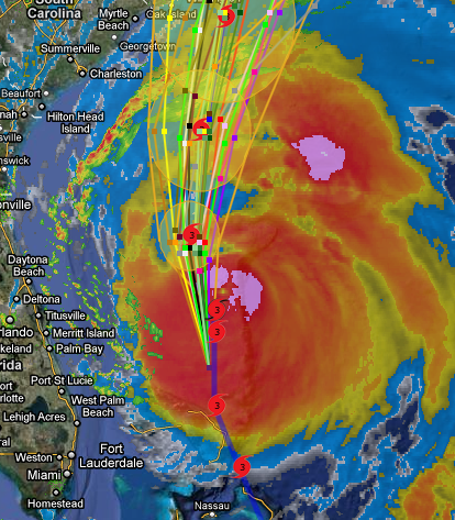
Hurricane Irene “Looking Bad” for U.S.—Moon May Make It Worse
Current forecasts suggest Irene will likely make landfall as a major hurricane on North Carolina’s Outer Banks barrier islands this weekend, bringing damaging winds and serious flooding to coasts from North Carolina to New England.
Hurricane Irene’s center is “likely to go through the Outer Banks and rake the coast all the way up—Virginia, Delaware, Maryland, New Jersey—all the way up to New England,” said Blackwell, of the University of South Alabama’s Coastal Weather Research Center.
“Long Island looks like it’s really going to be in trouble.”
However, Jack Beven, a hurricane specialist at the National Hurricane Center in Miami, pointed out that the margin of error for predicting hurricane landfall sites three days out is 150 miles (240 kilometers). This means that Hurricane Irene’s actual landfall could be that far east or west of the current predicted hurricane track.
As of 2 p.m. Thursday, Hurricane Irene’s eye was passing over the northern Bahamas and moving northwest at about 13 miles (21 kilometers) an hour.
Irene’s strongest winds around its eye were 115 miles (185 kilometers) an hour, making Irene a Category 3 hurricane on the Saffir-Simpson scale, which rates hurricanes from 1 to 5, based on damage potential.
Source
They are telling residents to keep their IDs in their left shoe just incase they need to identify bodies.. The IRS has also stated that your should copy and save your important documents to your computer or a CD. There is so much news on this subject; I can’t keep up with it all. The army will be blocking off roads everywhere and most of the roads that i’ve seen today are going only one way! Toll roads are free and they are telling everyone to leave NYC and the shore areas. Most people were so ignorant that they didn’t even know this storm was coming! Below I included some very important links and videos! You have to watch the one about the underground Nuclear Explosion and the one showing that this hurricane might be controlled by Chemtrails and HAARP! Since that ‘earthquake’ I knew something was up… Ill be updating this post as more information becomes available. Please be safe and check on your elderly neighbors. If you have any information or photos or even videos please send me an email at tips@usahitman.com – Keep a look out on the weather websites and new stations for up-to-date news. If you guys don’t hear from me, the storm has taken my life… Lets hope that doesn’t happen. Good Luck and Let the Truth Set You Free!
Links & Videos
Virginia & Colorado NUKED UNDERGROUND?
Hurricane Irene IS MAN MADE and being guided by HAARP!
Washington Reagan National Airport has been evacuated because of an odor of gas.
Damage Reports Around the Area
DC / Virginia Earthquake Aftermath (Video)
Minor damage found at quake epicenter (Lies)
Damage at the epicenter of the earthquake – 11 pm (Video)
Hurricane Irene IS MAN MADE and being guided by HAARP! (Video)
Did Comet Elenin cause the DC quake?
North Carolina governor suspends gun rights
Building damage in Baltimore (Video)
Moderate Quakes Striking Odd Places in USA…Coincidence Or Not?
Hurricane Irene survival guide
Baltimore Quake Damage (Video)
Bizarre USGS Omission of Phase Data and Historic Seismicity on DC 5.8 Quake Suspicious
Underground military base near VA quake epicenter? Peter’s Mountain
Obama Warns Hurricane Could Be ‘Historic’
HAARP is preventing damage, not creating it
Mancuso Says Hurricane Irene Rivals Katrina, Ike in Size (Video)
FEMA Preparing For Massive QUAKE & Meltdown – Rushing $15M Meals to NM Quake Zone
Hurricane Irene From Space – NASA (Video)
Military: Major General Glenn Rieth On Hurricane Irene (Video)
Irene: Worst Effects on Northeast in 50 Years Possible
A List of Webcams That Are Tracking The Storm
More than 500 inmates evacuated from Cumberland County state prison